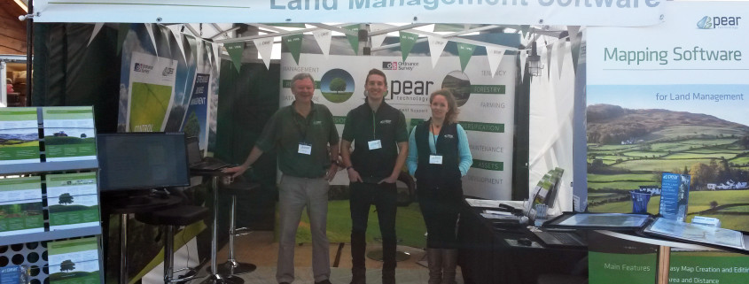
Pear Technology 20th Anniversary

Pear Technology 20th LogoWe are ecstatically proud to announce 2015 was a special year for Pear Technology as we celebrated our 20th Anniversary of providing land management software and digital mapping services!

Whether you are an existing or previous client, partner, or indeed someone we just like to keep in touch with, I’d like to give you the largest Thank You for your support and business over the past 20 years and on into the future as we make more developments and take increasing number of orders.

On our journey of GIS development and consultancy, we have become a devoted leading supplier of software and services to nearly 2000 loyal customers.

To our very first clients and to the most recent, your trust in our digital mapping solutions has made the celebration of our 20th Anniversary in 2015 possible! So again-Thank you!

Letter from our Managing Director, Chris Makin

As Managing Director of Pear Technology, I feel very honoured to have been given the opportunity to steer Pear Technology through the next phase of the company’s journey without the guiding light of our founder, John Cowling.

John has now officially retired from the day to day running of the company but his regular attendance at our quarterly operations meetings allows for an exchange of views and provides an arena for some strategic thinking. John has built up twenty years of knowledge about our market place and provides a good sounding board for new ideas and initiatives.

I am pleased to report that Pear enjoyed a very good trading performance for the year ending April 2015. The company posted its best ever sales performance resulting in year on year growth in turnover of 20%. We also added a further 186 new customers to our client base and maintained our relationship with our existing customers via our very personal Technical Support Service. The company was able to take on more staff during the year to support our business operations as well as providing work experience for a number of budding GIS experts still in education.

As with all companies that are pleasant to work with and within it is the people behind the emails and the website who make the difference. Here at Pear, we have a dedicated team of professionals who are prepared to go the extra mile to provide attentive customer support to our existing clients as well as drive long distances to give first hand demonstrations and training to our new and potential customers.

Finally I would like to add my thanks to all our customers for their continued support of our products and services and to all the staff at Pear, both past and present, who make coming to work at Pear a pleasure!

 Kind Regards

Pear Technology Managing Director

Chris Makin

Farm Business Innovation Show 2015 – 11th & 12th November

FBI Banner

Pear Technology are thrilled to announce that they will be exhibiting at the Farm Business & Innovation show on the 11th./12th. November at the NEC  in Birmingham.

The Farm Business & Innovation shows is a large event that keeps Farmers, Land Managers, Glampers, Campers, Estate Owners and all sorts of other people up to date with the latest software, products and services that are available to help them manage their land and assets. It really is a great opportunity to explore avenues that you may have never thought of before and the whole show is an extremely well organised event. An added bonus is the number of useful and interesting seminars which are held throughout the two days which are short, punchy and topical.

Pear will be exhibiting on Stand 442 promoting our mapping software, new available datasets and various types of GPS equipment. We are excited to say that we have a specialist from Leica exhibiting with us who will be demonstrating a new range of devices that Pear will soon be selling. Pear will be introducing a new service which is our very own online ‘MapShop’ which allows customers to purchase OS MasterMap and OS VML data for a user defined area, 24 hours a day.

The show is also a great opportunity to meet some members of the Pear team.  Freddie Ryan, who is managing the Farms and Estate Sector will be attending on both days along with a new colleague, Charlie Farrington, who is based down in the South West and has a strong background in the farming sector. In addition, the managing director Chris Makin, will be in attendance and is looking forward to  meeting all existing and new customers.

We look forward to seeing you at the show.

Admission tickets, which are free, can be obtained by following the link below:-

http://www.eventdata.co.uk/Forms/Default.aspx?FormRef=FBIB5Visitor

Public Rights of Way data now available for the majority of the UK

Public Rights of Way data has recently become much more widely available and Pear Technology are pleased to offer the service of adding this information to your digital map.

Available on various Ordnance Survey raster tiles, Public Rights of Way information previously had to be purchased then painstakingly traced leaving some degree of inaccuracy. It can now be added to your digital map on its own layer, making it much easier to display and edit on your map. In PT-Mapper Pro, one click can tell you how long the footpath is and another can show you the route in Google Earth’s aerial view.


Subject to the data availability, we can provide you with a layer for each classification of the Public Rights of Way. These are:

  1. Footpaths – for walking, running or mobility vehicles.
  2. Bridleways – for walking, horse riding, cycling or mobility vehicles.
  3. Restricted Byways – for any transport without a motor and mobility vehicles.
  4. Byways Open to All Traffic (BOAT) – for any kind of transport, including cars but mainly used by walkers, cyclists and horse riders.


Landowners have responsibilities for the Rights of Way which fall on their land. Knowing where these routes are is the first step in ensuring compliance with environmental law!


Did you know?

  • You are not allowed to grow crops on Public Rights of Way, although grass can be grown for hay and silage.
  • Footpaths and Bridleways may not be ploughed unless they cross fields. Landowners must then supply an access route 1m – 2m wide respectively within 14 days of ploughing.
  • You cannot put up gates or stiles without the local authorities permission.


If you would like Public Rights of Way information added to your map simply email info@peartechnology.co.uk or call us on 02392 499689 and we can check availability and provide a quote for the work.

Pear at the CLA Game Fair

Lizzy CLA

RPA – Basic Payments Scheme Deadline

2016 Update: Please note RPA boundaries in a shapefile format are no longer available. 


The Current Situation

With the announcement of the Basic Payment Scheme’s (BPS) withdrawal of their online mapping system, farmers are having to resort back to paper maps. Claim submission deadlines have been extended to the 15th June, 2015. However, the RPA have advised farmers to get their claims in as soon as possible  to make sure guidance can be given where needed.

The RPA have been issuing more details on how farmers can claim for the BPS 2015 and have been distributing pre-populated BP5 claim forms to all registered cutomers of the Rural Payments online system.


How Pear Can helpLaundry Cottage RPA

Paper maps are fine and a lot of farmers will resort back to this traditional method but it is far too easy to create inaccuracies when using a felt tip on a paper map. PT-Mapper in comparison allows you to accurately update your farm to the nearest cm if needs be giving you realistic and reliable readings for your claims.

The RPA analyse Ordnance Survey MasterMap data, the most up to date and detailed data avaialble from the OS,  to identify boundary amendments. The great benefit of our software is you can purchase the very same MasterMap data to check, identify and adjust your field boundaries to the appropriate position.

In addition to this, you can request your RPA field boundaries directly from the RPA in a ‘shapefile format’, for free.  These files can then be easily imported straight into PT-Mapper showing you your field boundaries as well as any permanent ineligible features (PIF’s). From here you can edit the boundaries to follow the MasterMap data, measure distances yourself for the boundary to follow, use a handheld GPS device to plot points to map to, or link your fields to Google Earth and follow the aerial imagery.

To go one step further you can use our easy-to-use editing tools to create accurate buffer strips around your fields to calculate the exact area being farmed as well as Game Cover and grass margins.

It is time to get your field boundaries up to date and PT-Mapper is the perfect, simple and intuitive replacement to the BPS’ withdrawn system.


How to get started

  1. Download a trial of PT-Mapper to see how you like the system. Once you are happy, get in contact with us to purchase a full licence.
  2. Request your RPA shapefiles from the RPA
  3. Send us a plan of your farm so we can provide you with a quote for the Ordnance Survey MasterMap data required.
  4. Use our software to edit your field boundaries and gain precise hectarage for your farm
  5. Print the updated maps and fill in your BP5 form with your accurate, up to date figures and make your claim


Related Products

PT Mapper

PT-Mapper is the core application to help manage land and assets through the power of maps. It provides much more than free online mapping services as well as all the key functions of more expensive geographic information systems. PT-Mapper brings together your own data with that of other agencies to allow for more effective and efficient decision making.

Arb Newsletter – May 2015


Events

Pear Technology will be exhibiting and giving demonstrations at the following events.


Month Date Event Location

Link

June Friday 5th
Saturday 6th
The Arb Show
Westonbirt Arboretum
GL8 8QS
http://www.trees.org.uk/training-events/The-ARB-Show
June Wednesday 17th Barchams
Big Barn Day
Ely, Cambs
CB7 5XF
http://www.bali.org.uk/news_events/events/946/barchams-2015-big-barn-conference
June Tuesday 30th Arb Association Scotland Royal Botanic Gardens Edinburgh EH3 5NZ
http://www.trees.org.uk/aa/branches/Scottish-SC.html
July / August Friday 31st – Sunday 2nd CLA Game Fair Harewood House, Leeds, LS17 9LG  https://cla.yourticketbooking.com/p/CLAGameFair?REFID=GFHomepage
September Thursday 10th
Friday 11th
Confor
Woodland Show
Longleat, Warminster, Wilts BA12 7NW http://www.confor.org.uk/NewsAndEvents/Default.aspx?pid=174
September Sunday 20th – Wednesday 23rd Arb Association Amenity Conference The University of Warwick, Arts Centre
CV4 7AL
http://www.trees.org.uk/Amenity-Conference

http://www.warwickartscentre.co.uk/your-visit/


Leasing

We are now able to offer 3 year leasing options for both hardware and software. This allows payments to be spreads and set off against tax.

For further details, see our web site, or give me a call – Jonathan Smith 07593 299752


Software Development
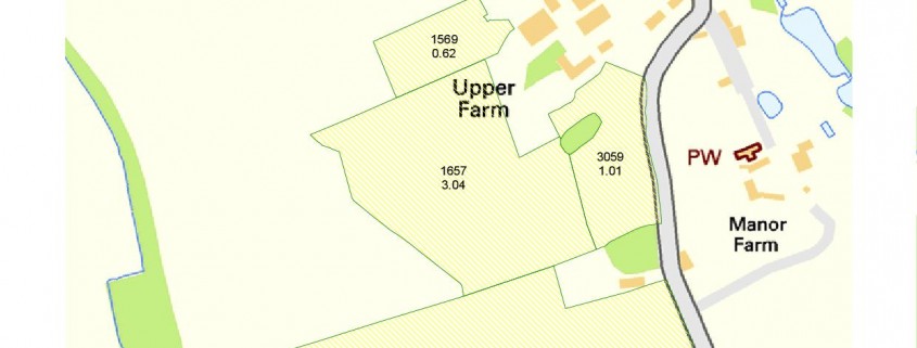
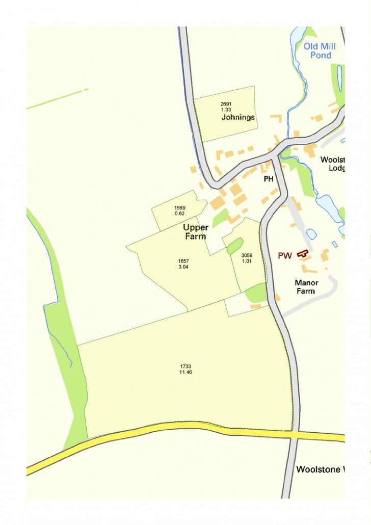
PT Mapper Pro

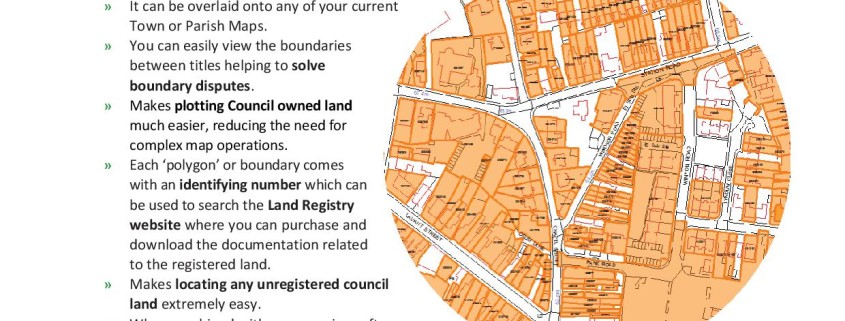
  • Markers Tool – Includes option to add grid reference coordinates as labels
  • New Tree legend template – includes templates without tree shadow.
  • Fixed problem to do with Ordnance Vector Map Local TIFF files not loading correctly.

MapLink

  • New draw circle tool added – allows units to be specified
  • Data verification – if 2 or more records have the same postcode there is now an option to click through all of them on the map pop up window
  • Off screen drawing is applied to all maps to improve the stability of the program while points and themes are being added
  • Fixed problems with the print screen tool

TreeMinder

In TreeMinder reports it is now possible to choose how the report is filtered. There are 2 options on the report selection page:

  • Filter Style: Loose. This option works by using the criteria to narrow down the list of trees, however all work items are then shown for those trees, for example if you choose Remove :: Minor Dead Wood then the report includes all the information for any tree that includes that work type in its work list. This can be useful as it allows the complete situation to be seen for the trees of interest.
  • Filter Style: Tight. This option applies the criteria more strictly and only shows information that exactly matches the criteria, for example if you choose Remove :: Minor Dead Wood then the report would only show that work item in its work list and any other work for that tree would be effectively hidden.
  • A custom footer can now be added. The details can be entered on the report selection page.


Case Studies

We are keen to collect case studies and will provide a reward for those used. (eg 50% discount off your next year’s technical support). Please contact us if you have any cases you would like to share.
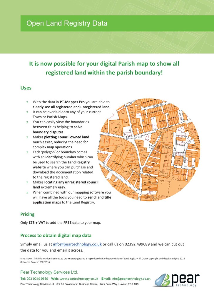
 

Map Shop


We are going to provide an online Map Shop and are inviting trial users – please let us know if you are interested.We have developed the  Map Shop to provide you with instant access to the latest Ordnance Survey map data, whenever you need it. You will also be able to produce  your own quotes before committing to buying the map. More details will be available soon.


Hardware Update

Android Pocket GIS is now becoming available – trial users are invited. Please let Pear Technology know if you are interested.

Trimble T41CG (default recommendation):

4.3″ screen, 800 x 480, Windows Mobile or Android option,

1-2 metre GPS 8mp camera, all day battery, IP68        £1,650

Panasonic Toughpad :

Windows 8 ,10″ screen, i5 processor, 3-5 metre GPS, IP65, 3 year warranty

http://business.panasonic.co.uk/computer-product/toughpad/fz-g1        £2,750

Getac T800:

Windows 8 tablet. 8″ screen 1280 x 800, 2.5m GPS

http://en.getac.com/tablets/T800/specs.html       £1,600

Getac Z710:

Android tablet, 7″ screen, 1024 x 600, 5mp camera, 2.5m GPS

http://uk.getac.com/tablets/Z710/specs.html         £ 995


Australian Version


We have now developed a version of our software for the Australian market and have a local distributor. If you would like further   details, or know of anyone in Australia who might benefit from our system, please let me know.


We would also be interested in rolling out our software to other markets and would be happy to receive suggestions.


Group Training Days

We are considering running group training days, allowing for economical training and sharing of best practice. A minimum 5 trainees would be required. Cost TBC. Please let me know if you might be interested.


Tenders/Leads

Brighton and Hove -arboricultural services, due 26.05.15 see: http://www.sell2wales.gov.uk/search/show/search_view.aspx?ID=APR080441

The Royal Parks – arboricultural advisory services, tender due 12.06.15: http://www.sell2wales.gov.uk/search/show/search_view.aspx?ID=MAY083526

English Heritage South East – Arboricultural Services – tender due 01.06.15: http://www.sell2wales.gov.uk/search/show/search_view.aspx?ID=MAY082484

Local Councils

We have 200+ Local Council clients. Many of them have responsibility for the trees in their parish and could benefit from your services. You can then update their maps and records with your survey results, using Pear Technology’s system.

If you already provide services to Local Councils, please let me know and I will exclude those councils from our mailing.

If you do not wish to be included in the list of Pear Technology arboricultural consultants, within 30 miles of a given Local Council, please let me know.

Data sets available at Pear Technology

​For more information on the Data Sets at Pear please see the links below:

 PT Info- RPA Maps

​​ PT Info- Land Registry

​​ PT Info- Open Land Registry

​​ PT Info- Data Sets

​​ PT Guide- OS data F&E

DOWNLOAD NOW PT-Mapper

Data Sets Prezi


​For more information on the Data Sets at Pear please see the links below:

 PT Info- RPA Maps

​​ PT Info- Land Registry

​​ PT Info- Open Land Registry

​​ PT Info- Data Sets

​​ PT Guide- OS data F&E

Farm Business Innovation and Country house Innovation Show

The Farm Business Innovation show is growing into its second year, Pear Technology will be exhibiting to share what we have been working on and what is happening in the world of mapping for rural market.

With last year’s success, the two days are expanding to incorporate the Country House Innovation show to host in one place everything innovative in the rural sector. As well as the exhibitors, there are going to be a diversity of speakers sharing the best ideas of rural development from the “Future of Diversification” to “How to grow your brand”. It promises to be a fascinating two days and best of all it is free for all to attend.

When:

Thursday 27th November 10am – 6pm

Friday 28th November 10am – 5pm

Where:

Olympia London, Hammersmith Road, London, W148UX


What Pear is doing at the show

Exhibiting

We will be showing how our software and services assist rural innovation and that as well as the latest Ordnance Survey large-scale maps, there is an increasing supply of freely available Governmental map data available to take advantage of. Access to this data from Land Registry, the Environment Agency, Forestry Commission, Natural England, RPA is a key part of rural business management, and our products and services are designed to make this as useful as possible to you.

Seminars

We have been asked to present two seminars describing how the world of mapping and GIS is evolving for farms and estates, and the opportunities that are now at your fingertips.

Pear Technology’s Farm Business Innovation Seminar. Find out more.

Pear Technology’s  Country House Innovation Seminar. Find out more.


Take a day or two out in London to experience the latest innovations taking place in the rural sector. It is going to be a great couple of days uncovering the latest ideas and opportunities available to you and your business. We look forward to seeing you there.

Getting free tickets

To get your free ticket for the show follow this link.

Links

Farm Business Innovation Show- http://www.thefarmingshow.co.uk/

FBI Seminars- http://www.thefarmingshow.co.uk/seminars/

FBI Free Tickets- https://tickets.prysmgroup.co.uk/farming/119/

Country House Innovation Show- http://www.countryhouseinnovation.co.uk/

CHI seminars- http://www.countryhouseinnovation.co.uk/speakers/

CHI Order Free Tickets- https://tickets.prysmgroup.co.uk/ctry/127/

The CLA Game Fair – 18-20 July 2014

oslp_003

What a great show the CLA Game Fair was. It was wonderful to meet so many new people and see so many existing customers. With all our new digital mapping options for estate and farm mapping there was a lot to talk about. The Basic Payment Scheme mapping was a hot topic and there is more to come on that front.  Get in touch with Pear if there is anything more you would like to know.

samsung_galaxy_note_8.0 copyWin a tablet

We are developing some great new ideas that utilise mobile technology to ensure you always have the right information wherever you are. To help you get the full picture we’ll be giving away a Galaxy Tab II smart tablet. Just enter your details below to enter the draw.

Error: Contact form not found.